The Cooperative National Geologic Map is cool, but what happened half-way across PA: no more data?
Saturday, August 30, 2025

Friday, August 29, 2025
Projections & Distances
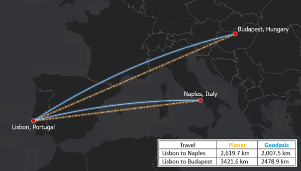
Geodesic or planar: which to use for distance analysis (by Esri) is a nice overview of the issue. Take-home message: use geodesic distances!
Thursday, August 28, 2025
Forms in ArcGIS Online & Beyond!
Nice summary & overview here: Comprehensive Guide to Forms in ArcGIS Online
- Basically you can use Forms within ArcGIS Online / Map Viewer to edit feature layers (digitize new features, input/edit attribute data, etc.).
- And: you can use Forms for field data collection using ArcGIS Field Maps.
Tuesday, August 26, 2025
Sketchfab & Cannon Mountain
Sketchfab looks fun & calls itself "The leading platform for 3D & AR on the web". The free plan may be enough to get you started, but anything after that is $15 / month.
Here's an example: Cannon Mountain (New Hampshire)
Monday, August 25, 2025
GIS Certificate @ CCSU
Looks like they are running a 3-course GIS Certificate:
- Beyond the Map: Advanced GIS in Action
- GIS Advanced Certificate course
- GIS Essentials Certificate - Course 1 Fundamentals
They seem to have an Introduction to GIS & an Advanced GIS course - not sure what the 3rd course required course this.
Back in the days: a Bachelor's degree was 120 credits, the Gen-Eds were 40 credits, the Major was 40 credits, the Electives were 40 credits, a Minor was 18 credits, a Certificate was 12 credits, and 1 full-semester course was 3 credits. Yes, there were some variations, but that's about what you could expect a normal public college or university.
Now the trend is towards 90 credits for the Bachelor's degree (completed in 3 years), Minors with 15 credits, and Certifciates with 9 credits.
Subscribe to:
Posts (Atom)