- Summary in Nature
- De Soto, P., Pažout, A.,Brughmans, T. et al. (2025) Itiner-e: a high-resolution dataset of roads of the Roman Empire. Nature Scientific Data. https://doi.org/10.1038/s41597-025-06140-z
- https://itiner-e.org/
Showing posts with label DH. Show all posts
Friday, November 7, 2025
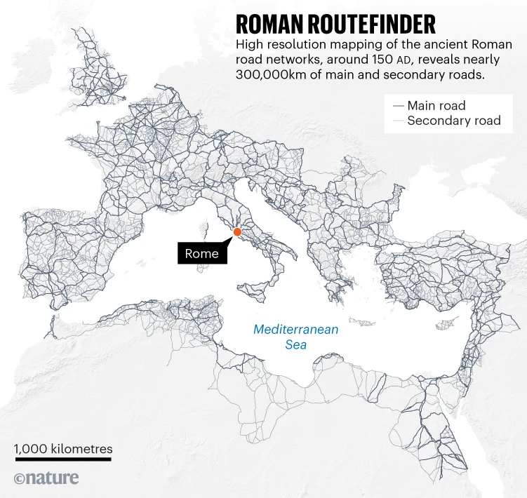
The Romans Google Maps!
This is really cool: a high-resolution digital map allows people to plan their routes along the ancient roads of the Roman Empire.
Tuesday, August 22, 2023
Photogrammar
Photogrammar (by Yale University) is classic DH: mapping 170,000 photographs taken between 1935 and 1944.
Wednesday, May 31, 2023
Mapping 1,001 Novels
Great example of the digital humanities: 1,001 Novels: A Library of America, presented as an Esri Story map. I tried something like that here for a single book: The Bonobo and the Atheist Story Map.
Tuesday, May 2, 2023
Mapping Books
Seen on Maps Mania: A Visual Book Recommender is an interactive map of 51,847 books organized by similarity. Using the map you can discover new books to read by searching for your favorite books and exploring other 'similar' nearby books.
Friday, January 28, 2022
Mapping Textbooks / Libraries
These two 'maps' are pretty cool:
- Open Syllabus Galaxy: This interactive 'map' shows the 1,138,841 most frequently assigned texts in the Open Syllabus corpus, a database of 7,292,573 college course syllabi.
- HathiTrust Digital Library
Monday, January 10, 2022
Historical OSM
This is cool: OpenHistoricalMap. Let's put South America on this map!
Monday, January 18, 2021
Decolonizing Data Viz
Good article by Stephanie Evergreen: Decolonizing Data Viz. Read and then move-on to Data Feminism by Catherine D'Ignazio and Lauren Klein.
Sunday, December 6, 2020
Living Nations, Living Words
Living Nations, Living Words is a nice Story Map of First Peoples Poetry.
Friday, November 20, 2020
Mapipedia
Mapipedia is a new interactive map which can help you map and share your geotagged photos. That's all: funs and even a little useful. Here's a demo: https://mapipedia.com/s/u/drdave/demo.html
Friday, September 11, 2020
Historic Streetview
Streetview is great, but what about the past? Here are two options:
- Chronobook is great - make sure that you zoom-in enough as photographs and entire collections may pop-up.
- Historypin is a similar approach.
Obviously you will get a lot more results in populated urban areas.
Tuesday, March 3, 2020
Scribbling
Here are two fun and simple tools that allow you 'scribble' (= annotate) maps (seen on Maps Mania):
Fun and maybe useful in the context of the Digital Humanities.
Saturday, August 24, 2019
Slavery in the USA
Great story map from USA Today and a nice examples of the so-called digital humanities (DH): Slavery's explosive growth, in charts: How '20 and odd' became millions.
Saturday, August 3, 2019
Mapping American Artists
Here is a nice example of DH by the NYT.
Saturday, June 8, 2019
Timeline JS and Storyline JS
Storyline JS is a fun tool: take a simple Google Sheet with time series data and annotate dates/times of interest with interactive cards. That's it. Simple.
Timeline JS is similar, but offers more features with embedded media to illustrate events over time.
Both are in a sense story maps, but here the main organizational frame is time, not space.
Timeline JS is similar, but offers more features with embedded media to illustrate events over time.
Both are in a sense story maps, but here the main organizational frame is time, not space.
Tuesday, June 4, 2019
Friday, May 31, 2019
Geography and Poetry
Or: poetry about place and places - a great DH example.
- Places of Poetry
- Poems about Places: The Poetry Atlas
Saturday, November 3, 2018
The American Experience in 737 Novels
The American Experience in 737 Novels is a nice Esri Story Map and a great example of the so-called digital humanities.
Tuesday, October 23, 2018
Lynching Maps
Maps Mania has compiled three maps related to this topic. Personally I find the simple dot map especially intense because it is 'just' a simple dot map: One Dot for every Lynching Victim in the US 1883-1930.
Thursday, September 20, 2018
DRAW
DRAW stands for 'Data Rescue: Archival and Weather', allows volunteers to participate in the transcription of historical weather logs captured at the McGill weather observatory since 1863. The weather information contained in these logs needs to be transcribed in a digital format in order to be used for scientific research.
Thursday, August 23, 2018
Digital Mappa
Digital Mappa looks pretty cool - from the website:
Digital Mappa is a freely available online environment for creating projects out of digital images and texts. The premise of DM is simple and powerful: if you have a collection of digital images and/or texts, you should be able to produce an online resource that links together specific moments on these images and texts together, annotate these moments as much as you want, collaborate with others on this work, have the content you produce be searchable, and publish this work to others or the public as you wish. And you should be able to do this with little technical expertise.
Subscribe to:
Posts (Atom)
