
Showing posts with label Projections. Show all posts
Showing posts with label Projections. Show all posts
Thursday, January 29, 2026
The Oldest Globe
As seen on Maps Mania: the world’s oldest surviving terrestrial globe from 1492 that obivously does not yet include the Americas!


Saturday, December 6, 2025
Tuesday, November 4, 2025

Friday, September 19, 2025

Friday, September 12, 2025
The Correct Map
Notthing really new here, but a few nice resources:
- The Correct World Map
- The “correct” map
- A cool scrolly-type story map: The true size of Africa
- The Equal Earth Projection
TLDR? Here's the short version: It is mathematically impossible to transform the surface of a sphere on a 2D surface without distorting at-least one of these properties: 1) angles, 2) shapes, and 3) distances. These distortions are minor at large-scales (e.g. neighborhoods or cities), but considerable at small-scales (e.g. countries, continents, or wolrd). Catographic projections need to balance these distortions in-order to make the map as useful as possible for its intended purpose. Therefore, there is no such thing as a 'correct' map: every map is wrong, but there are well-established cartographic projections that are most-suitable for certain applications.

Friday, August 29, 2025
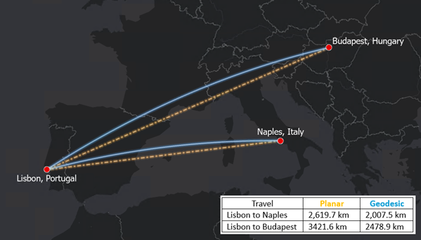
Projections & Distances
Geodesic or planar: which to use for distance analysis (by Esri) is a nice overview of the issue. Take-home message: use geodesic distances!
Friday, May 16, 2025
Maps: Projections & Distortions
Here you can make your own version of reality: Country Centered Map Projections
- Select your projection.
- Select your map center.
- Make things really weird by adding a rotation or two.
- Share as link or PNG.
- Awesome!
Saturday, April 20, 2024
Tuesday, September 26, 2023
Tuesday, May 3, 2022
Compare Map Projections
Compare Map Projections is fun: here's the classic Gall-Peters vs. Mercator comparison.
Sunday, April 3, 2022
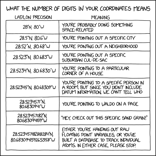
What precision do you need?
Great simple table showing the distance represented by decimal degrees - obviously this works anywhere for latitude, but is only correct for longitude at the equator because the line of longitude conerge towards the poles.

Source: https://community.esri.com/t5/education-blog/a-set-of-activities-for-teaching-core-content-from/ba-p/1139408 (Page 30)

Wednesday, September 29, 2021
The Projection Playground
The Projection Playground is fun: look at the world in different projections & you can even adjust the projection parameters to make things even more complicated. Plus you can get the D3 code.
Now: what is this useful for? No idea. For me, there are three challanges related to map projections:
- Make students realize that what (they think) the world looks like is actually just a function of the map projection / parameters.
- Understand the implications of 1).
- For students in my GIS courses: Be able to project GIS data (although that's become less and less important.
Thursday, April 1, 2021
Latitude / Longitude
There are many ways to figure-out the latitude and longitude for locations, but this one has to be one of the simplest: https://what-two-figures.glitch.me/
Thursday, February 25, 2021
Thursday, December 17, 2020
The Best Projection?
Choropleth maps (also called thematic maps) visualize data as a function of geographic areas and, as with every map, you need a projection to convert the 3D shape of the earth to the 2D shape of your screen or piece of paper. This is not really an issue when mapping a small area (say census tracts in Massachusetts), but becomes an issue when mapping at the scale of the plant.
Designing choropleth maps: What projection to choose? tries to figure-out what map projection is the best. Obviously it has to be an equal-area projection, but which one?
For me: Equal Earth or Mollweide.

Thursday, January 2, 2020
The Mercator Map of the Arctic
Seen on Maps Mania: The Mercator Map of the Arctic. Nice interactive overlay - make sure you adjust the opacity!
Thursday, November 21, 2019
Mercator, it's not hip to be square
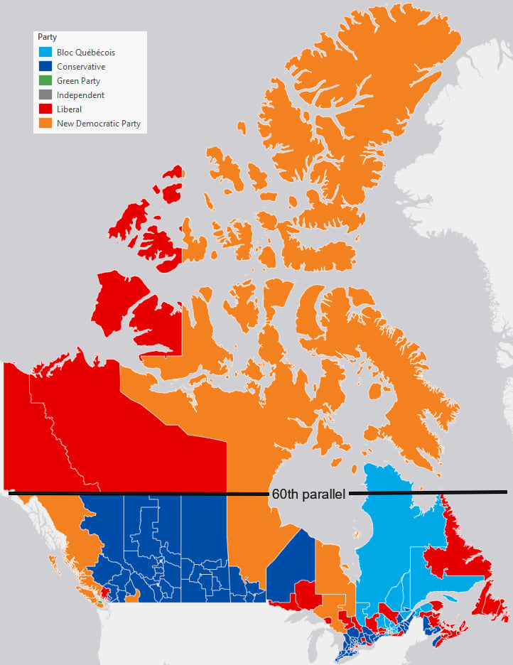
Good stuff from Ken Field: Mercator, it's not hip to be square. Quote: "Simply put, Web Mercator kills thematic maps." Perfect example: 2019 Canadian election maps.
Friday, October 18, 2019
Atmosphere, Oceans, and Continents
The EarthWindMap (https://earth.nullschool.net/) is awesome, especially the ability to visualize different atmospheric levels and weather variables. Now we have KCM-earth to compare ocean and wind currents between today and the Early Cretaceous.
Tuesday, September 10, 2019
Mercator (again)
Mercator - It's flat, flat world is a nice immersive story map that nicely describes and illustrates the history of this map and map projection.
Wednesday, July 31, 2019
Subscribe to:
Posts (Atom)