Tuesday, October 12, 2021
Monday, October 11, 2021
The Climate Accountability Institute
The Climate Accountability Institute has been around for a while: checkout their work on the so-called 'Carbon Majors'. What they really could use is some help with their data viz...here's one of their key tables: Top-20 1965-2018 Carbon Majors
Wednesday, October 6, 2021
The Human Ecological Niche
Turns-out that humans (like any other species) have a preferred 'ecological' niche at ~13 deg C MAT. And, 13 deg C also turns-out to be the optimmum for economic productivity. There are a lot of issues with such statements and Xu et al. (2020) do a good job offering context and discussion to their analysis. The figure below from the NRDC offers a nice summary.

Monday, October 4, 2021
NetCDF, Climate Data, and Satellite images
How to create multidimensional raster data is excellent and shows you how to handle multidimensional raster data in ArcGIS.
- Open a NetCDF file and map / analyze it. Great for gridded climate/ocean data or GCM outputs.
- Combine a bunch of Landsat 8 images into a multidimensional raster 'cube' - that keeps all your satellite images neatly organized and you can run your geoprocessing / raster functions on the cube as oppposed to on each raster individually. Cool!
Saturday, October 2, 2021
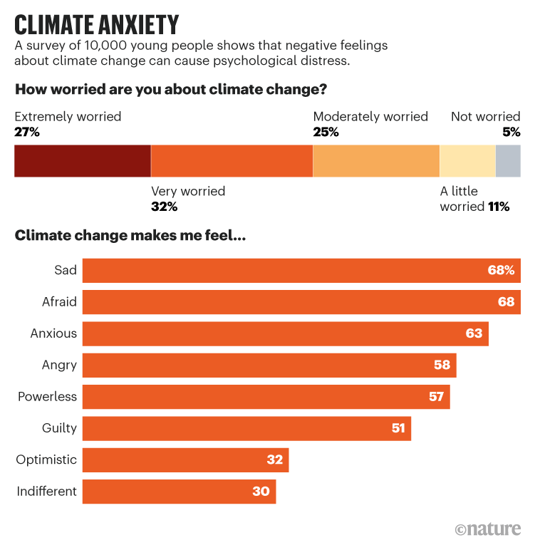
That's A Problem!
Source: https://papers.ssrn.com/sol3/papers.cfm?abstract_id=3918955. For context: Young people’s climate anxiety revealed in landmark survey (Nature, 30 September 2021).