- Felt seems like an online web mapping platform to accompany QGIS?
- Seems like they want to position themselves between the Nat Geo Map Maker (= no analysis) and ArcGIS Online.
- Not sure if I would be willing to put my work on a start-up like Felt that may disappear in a few years.
Showing posts with label QGIS. Show all posts
Showing posts with label QGIS. Show all posts
Monday, November 13, 2023
Felt
Felt proclaims it self to be "A better way to work with maps. Powerful enough for GIS Pros, easy enough for everyone else". Well, maybe.

Wednesday, August 30, 2023
Open Pedagogy in GIS Education
Have a read: The next layer: Towards open pedagogy in geospatial education (Abernathy 2023). A few comments:
- There's nothing inherently 'bad' about commerical GIS products (= Esri products) and there's nothing inherently 'better' about open-source GIS products - it's all in the way that you use them for teaching & learning.
- GIS teaching & learning does not all of the sudden become 'active' or 'inquiry-based' or 'diverse' or 'participatory' when you use QGIS & an open-source book.
- The vast majority of employees that hire my students use Esri products.
- The biggest challanges for open-source GIS products: 1) there is no pratical solution for a Web GIS and 2) for GIS apps.
- I will continue to use the Esri GIS products.
Thursday, February 2, 2023
Sunday, February 28, 2021
QGreenland
QGreenland is a free mapping tool to support interdisciplinary Greenland-focused research, teaching, decision making, and collaboration and combines key datasets into a unified, all-in-one GIS analysis and visualization environment for offline and online use.
Monday, November 9, 2020
Scientific Color Maps
When it comes to color (in maps, charts, etc.), ColorBrewer 2.0 has always been one of the go-to-resources. Now there's a new one: scientific color maps.
- The misuse of colour in science communication (Crameri et al. 2020)
- Scientific Colour Maps (website)
- Colour Maps (YouTube)
Thursday, March 26, 2020
QGIS & GIS Cloud
QGIS is great and now has a plug-in to publish maps to GIS Cloud. That's great. But...also highlights one of the issues with QGIS: you need to pay a commercial business to host your web maps (unless you are willing and able to run your own GIS web servers).
Tuesday, December 17, 2019
Green Mountain Maps
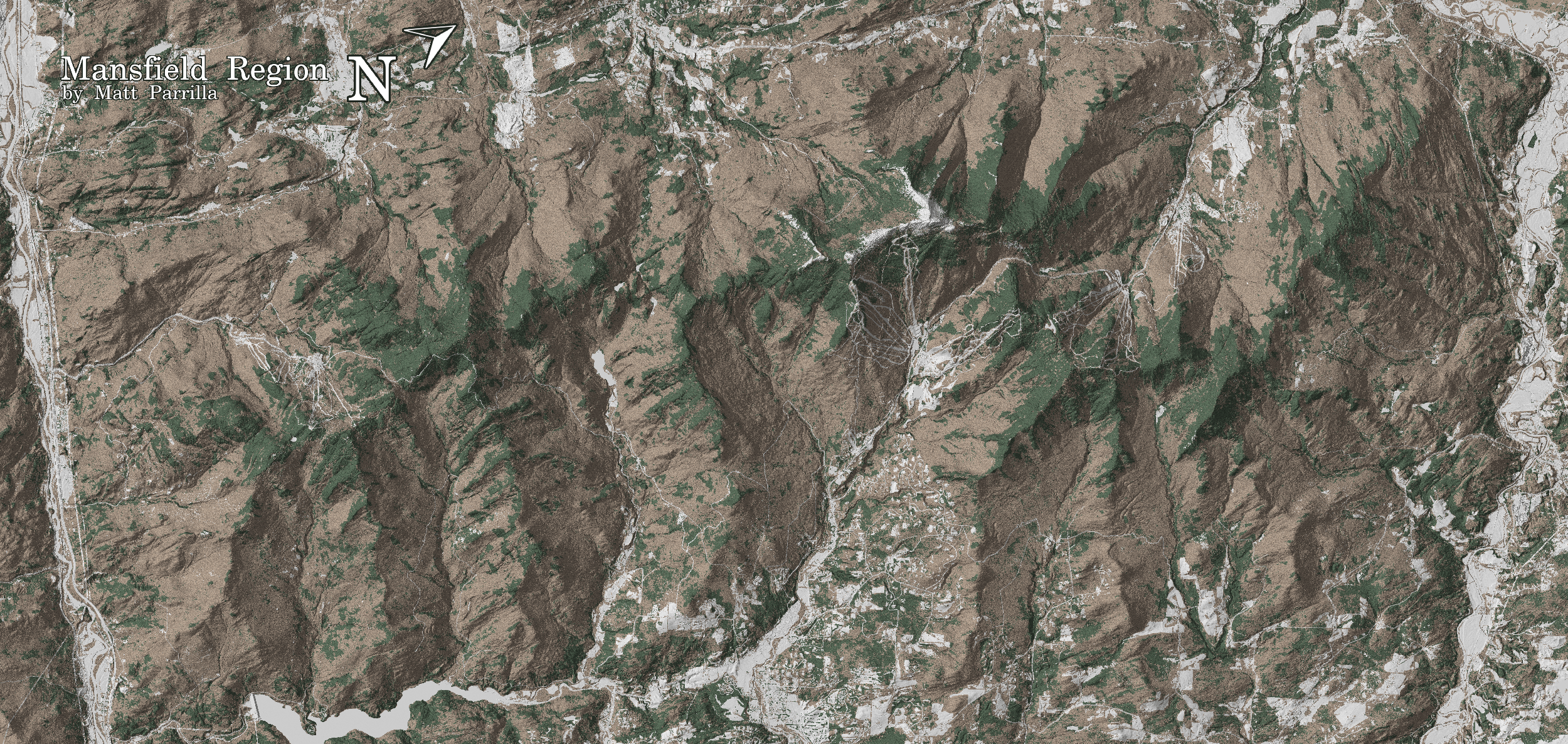
Nothing really 'fancy' here, but Green Mountain Maps is a nice use of open-source data for a specific purpose (here tree skiing in Vermont).
Thursday, July 26, 2018
QGIS 3 Beginner's Basic Tutorial
The QGIS 3 Beginner's Basic Tutorial is a nice and quick way to get to know QGIS.
Tuesday, July 3, 2018
FloodRisk
FloodRisk is a plugin for QGIS to quantify flood impacts and risks. Here are a few papers using FloodRisk:
- FloodRisk: a QGIS plugin for flood consequences estimation (Mancusi et al. 2015)
- FloodRisk: a collaborative, free and open-source software for flood risk analysis (Albano et al. 2017)
- Using FloodRisk GIS freeware for uncertainty analysis of direct economic flood damages in Italy (Albano et al. 2018)
Monday, July 18, 2016
The FOSS4G Academic Curriculum
Well, why not? The FOSS4G Academic Curriculum and associated open-source tools are great, but have one major flaw: the world is dominated by Esri products and therefore any responsible academic program has to include them in an appropriate way.
Friday, June 3, 2016
Tuesday, January 26, 2016
A Journey of a Thousand Map Units Begins With a Single Dataset–GIS 101 is a nice introduction to GIS using QGIS.
Friday, November 27, 2015
Learn QGIS
Five free QGIS courses (self-taught at your own pace) - more information about the curriculum and content at the FOSS4G Geoacademy Curriculum.
Thursday, March 26, 2015
Tuesday, March 17, 2015
Saturday, March 14, 2015
Science Mapping
Nature has a nice article by Mark Zastrow Data visualization: Science on the map as part of their Toolbox section featuring scientific software, app, and online tools. The focus is perhaps too much on TileMill and CartoDB, but still a worthwhile read.

Friday, March 6, 2015
QGIS
That's nothing new - QGIS is a very capable open-source alternative to Esri - actually, in practice, probably the only realistic way to avoid Esri products as MapWindow seems to be stalling these days.
- Full QGIS Training Manual (includes PostgreSQL and PostGIS) - also available in print.
- QGIS Uncovered (excellent 25-part video tutorial by Steven Bernard)
Thursday, February 26, 2015
GIS and Geography MOOCs
Early 2015:
- Geospatial MOOCs
- Introduction to Geospatial Technology Using QGIS
- Skills for the Digital Earth (Elmhurst College)
- Fundamentals of GIS for Conservation (6 modules from the Nature Conservancy)
- Going Places with Spatial Analysis by Esri (upcoming, course outline).
- Geospatial Intelligence & the Geospatial Revolution (starting 14 January 2015)
- Introduction to GIS using gvSIG (24 November to 20 December 2014)
- From GPS and Google Maps to Spatial Computing (started 23 September 2014)
- Desktop GIS from Peggy Minnis at Pace University (started 1 September 2014, read syllabus here and enroll here)
- Teaching Geography for the 21st Century (started 3 September 2014, more about this course from Joe Kerski)
- Introduction to GIS and Mapping by Open Online Education (started 1 September 2014)
- GPS: An Introduction to Satellite Navigation, with an interactive Worldwide Laboratory using Smartphones by Stanford via Coursera (starts 13 October 2014).
- Exploring Geographic Information Systems by Simon Fraser University. (Self-paced, but currently closed).
- Introduction to Geospatial Technology using QGIS (and other open-source GIS courses under Academy Links, also great tutorials and labs on YouTube).
- Maps and the Geospatial Revolution by PennState via Coursera (just finished).
- Geodesign: Change Your World by PennState via Coursera (just finished.
- Skills for the Digital Earth by Elmhurst College via Desire2Learn (just finished).
For a discussion of MOOCs, GIS, and Online Education in general consider "Crossing Borders" (a column by Doug Richardson in ArcNews Summer 2014).
Subscribe to:
Posts (Atom)