Showing posts with label Topography. Show all posts

Saturday, October 17, 2026

The 2026/2027 'Super' El Nino

Fact: the current SSTs in the eastern tropical Pacific are about 3 deg C higher than normal and that's more than 1 deg C warmer than the powerful 1997 & 2015 El Ninos. So, what can we expect?
  1. Droughts in southern Africa (e.g. Malawi, South Africa, etc.).
  2. Dry conditions & wild fires in Indonesia, Malaysia, etc.
  3. Dry conditions & wild fires in the Amazon region.
  4. El Nino years, and especially the year after an El Nino year, are generally hotter on a global scale - so expect 2027 to be anothe record year.

This sea surface elevation comparison (1997 vs 2026 El Nino) from NASA is great: https://science.nasa.gov/earth/earth-observatory/el-nino-then-and-now/

Tuesday, September 29, 2026

Relief

Relief is simple & cool: just the topography as you zoom & pan around the world. Share as link or export as image & video. One gripe: the color ramp is not that great - something more 'natural' for elevtion would be better I think.

Tuesday, July 14, 2026

Flow Maps

Flow Maps are cool, but really tricky to actually design & make look good. Here are two good resources:
  • Flow Maps (by Esri) shows some hacks in ArcGIS Pro & ArcGIS Online that can be used to make flow maps.
  • Flow Mapping (by PennState) is a great overview & introduction.

Thursday, February 13, 2025

3D Print Your World

Great compilation of tools by Maps Mania: 3D Print Your World
  • Topography Explorer
  • DEM Net Elevation API
  • Tiel Exporter

Thursday, January 30, 2025

Monday, August 26, 2024

How Smooth Is The Earth, Really?

How Smooth Is The Earth, Really? is a cool 3D animation of Earth's topograhy (both to-scale & with vertical exaggeration). This would be great as two amimated GIFs to show side-by-side.

I actually like the chart even more - showing the layers of the Earth to-scale & showing how insignifcant Earth's topography is relative to the size of the Earth overall.

Monday, August 19, 2024

NASA Earthdata

NASA Earthdata appears to be the (new) data portal for accessing all kinds of NASA data.

  • NASA Worldview offers full-resolution, global satellite imagery from over 1000 data products from NASA’s Land, Atmosphere Near real-time Capability for EO (LANCE) and other NASA data providers.
  • NASA Earthdata Search gives access to everything.

Saturday, March 4, 2023

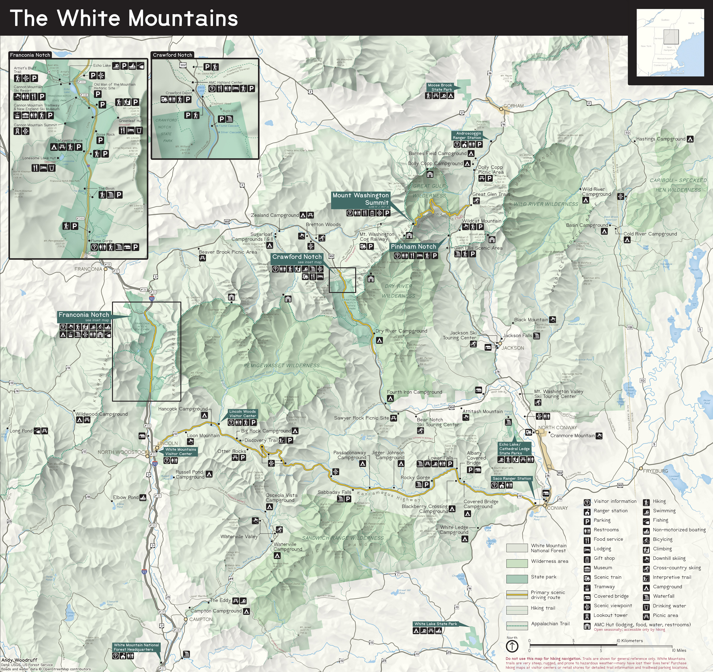
The White Mountains Maps

Great design by Andy Woodruff - a new map of the White Mountains in the style of the classic US National Park maps: White Mountains "National Park" Map.


Monday, February 13, 2023

Monday, November 21, 2022

Global Watersheds

Global Watersheds is great: delineate watersheds and downstream traces - downloadable in various geospatial formats & much faster than the corresponding Esri geoprocessing tools.

Sunday, November 13, 2022

River Runner

River Runner is fun - follow a drop of water as it travels downstream from whereever it falls.

Sunday, April 3, 2022

Need Contours?

Try Axis Map: https://contours.axismaps.com/#13/42.6111/-72.5949 (here centered around Greenfield, MA). A few comments:
  • You need to set an appropriate contour interval for your overall topography.
  • I can 'see' the label or roads - not sure what's happening here.
  • Export as vector, image, or GeoJSON - great!


Sunday, December 19, 2021