Showing posts with label apps. Show all posts
Showing posts with label apps. Show all posts
Wednesday, April 1, 2026
Cartokit
Cartokit is a direct manipulation programming environment for interactive cartography on the web. Vey cool! See more over on GitHub: https://github.com/parkerziegler/cartokit

Tuesday, November 4, 2025
ToolUniverse
ToolUniverse is a unified ecosystem that transforms any large language model (LLM)—open or closed—into a powerful AI scientist. By standardizing how LLMs identify and call tools, it integrates over 600 scientific resources, including machine learning models, datasets, APIs, and analysis packages.
With its AI-Tool Interaction Protocol, ToolUniverse provides a common interface for seamless communication between LLMs and tools, ensuring compatibility across platforms such as GPT, Claude, Gemini, and open-source models.
More over here: ToolUniverse Documentation
Tuesday, August 12, 2025
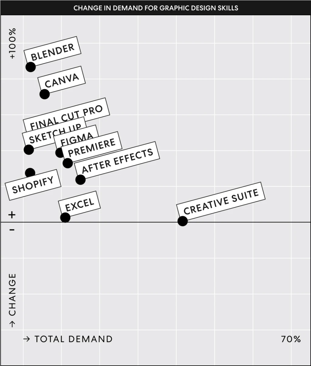
Blender & Canva
Sounds like Blender & Canva are taking over the 3D & 2D graphic design world - interesting! I'm not surprised to see Blender here, but Canva used to be considered an amateur tool. Read more about it here.
Sunday, June 29, 2025
The Retro Weather Channel
This is fun: display NWS data using the retro look of the Weather Channel back in the days: https://weatherstar.netbymatt.com/
Saturday, April 12, 2025
How Fast Is the Earth Spinning Where You Are?
Cool little web animation - use it to better understand the Coriolis Effect: How Fast Is the Earth Spinning Where You Are?
Saturday, March 15, 2025
Thursday, February 13, 2025
3D Print Your World
Great compilation of tools by Maps Mania: 3D Print Your World
- Topography Explorer
- DEM Net Elevation API
- Tiel Exporter
Sunday, January 26, 2025
Padlet!
Ah yes...we all used Padlet during COVID, but many of us (certainly me) have stopped using Padlet now that we are F2F again. But Padlet still works great, for example:
- Video Discussion Board where the students post one relevant video for a topic, for example ozone & global warming.
- Or, do the same with figures.
- There is also a Video Recorder where they could record a brief video of themselves talking into the camera.
Unfortunately, the free version of Padlet is limited to just 3 'padlets'...not sure how you could in-practice use that for daily teaching.
Monday, June 3, 2024
Hurricanes & You
Here are two nice web apps to explore hurricanes that impacted your particular area:
A little odd: Hurricanes Diane & Connie (August 1955) seem to be missing for my area here in Western MA & northern CT?
Thursday, August 31, 2023
Esri App Builders
This is helpful: Which App Builder Do I Choose?
- You have a web map & want to share it in a cool way: use Instant Apps.
- You want to tell a story & offer context for a general audience: use StoryMaps.
- You have real-time / continously updated data & want to share it with a specific audience: use Dashboards.
- You want the kitchen sink: use Experience Builder.
Basically use Instant Apps or StoryMaps if you want a general audience to interact with maps and use Dashboards or Experience Builder if you want a more specialized audience to interact with data as charts and tables.
Thursday, February 2, 2023
Tuesday, September 6, 2022
Wednesday, August 31, 2022
The New Way To Publish!
This is great! First, you have an allroud excellent paper, published OPEN in Nature Medicine. Second, you get a cool animated data viz where you can drill into the data and results yourself. Now all you need to add is a simple Data Download button and this would be perfect. Have a look:
Kephart, J.L., Sánchez, B.N., Moore, J. et al. City-level impact of extreme temperatures and mortality in Latin America. Natire Medicine (2022).
Tuesday, February 1, 2022
Mentimeter
Mentimeter looks fun - basically a combination of Kahoot!, PowerPoint, and Padlet. The free version is very limited, but should be enough for a class when combined with a 'real' presentation software, especially when teaching online. The paid versions are too expensive for an educator.
Sunday, April 11, 2021
ArcGIS Quick Capture
ArcGIS Quick Capture is a fun app and allows for quick and simple field data collection, for example photographs.
Saturday, March 6, 2021
High Tide Flooding
Also called nuisance flooding or sunny-day flooding - one of the first and most-noticeable impacts of global warming and associated sea-level rise. The High Tide Flooding App is pretty slick and you can look at different high tide flooding probability scenarios through 2100.
Thursday, March 4, 2021
Saturday, February 6, 2021
ArcGIS Field Maps
ArcGIS Field Maps is the new mobile data collection app from Esri - basically replacing the old Collector app. It all seems to work just fine as one would expect, but unfortunately my iPhone is too old to run the app. Here are some resources:
- Try data collection in ArcGIS Field Maps (the full workflow)
- Create a map for data collection in Field Maps (this is a little tedious using feature layers)
- Configure maps for the field (this should be obvious: offline mapping and downloadable map areas)
- Take Your Web Maps Offline with ArcGIS Field Maps (detailed PDF)
- Introducing smart forms in ArcGIS Field Maps (seems cool)
Monday, December 14, 2020
Esri Field Maps
Esri Field Maps is the new field mapping app - basically the 'new' version of Collector for ArcGIS. Unfortunately my old iPhone / iOS cannot run it...but here are 5 things to try in Field Maps
Subscribe to:
Posts (Atom)