Wednesday, December 30, 2015

Homo Sapiens - Child of the Ice Age

Homo Sapiens - Child of the Ice Age is an interactive 'story map' where you can trace and visualize the connections between human evolution and climate change over the last 4 million years.

The New Normal

Extreme heat events are more frequent by WXshift is a nice illustration of the so-called New Normal.


Scale of the Solar System

Global View: Climate Change in Perspective

Global View: Climate Change in Perspective by BloombergView is a nice and simple story map with a minimalist layout and design.

2014: The Hottest Year

This may have to get updated once the data for 2015 are all analyzed, but 2014 Was the Hottest Year on Record is a great visualization!

The Swiss Topography in 3D

Super-cool: Swiss Topo

GPS Radio Occultation

For GPS users the atmosphere introduces errors, but someone's errors are other people's treasure: weather forecasting using GPS radio occultation and CubeSats, in-essence a new way to get massive amounts of atmospheric profiles from all over the world.


Earth Primer

Earth Primer looks great - a geology 'textbook' that explains and simulates the ways in which lava, wind, temperature, and water shape our planet. The built-in simulator puts geological forces at your disposal to carve out canyons, grow volcanos, smash continents together, and more. Read more about it here.

Earth, A Primer — App preview from Chaim Gingold on Vimeo.

IR Thermometers for Smartphones

I'm always intrigued by IR thermometers that can be viewed via a smartphone - these can be great teaching tools when explaining the concepts around electromagnetic radiation - here are three options:
  1. The Ryobi Phone Works IR Thermometer and App ($40)
  2. The SEEK Compact or Compact XR ($249/$299)
  3. The FLIR ONE ($249.99)

Thursday, December 17, 2015

2000 Years of Urban Growth in 3D

2000 Years of Urban Growth in 3D is cool, but I agree with Maps Mania: no need for a map and certainly no need for a 3D globe.

Why Do Rivers Have Deltas?

Historical Geography of the United States

Here is the digital version of Charles O. Paullin and John K. Wright's Atlas of the Historical Geography of the United States, first published in 1932, beautifully prepared by the Digital Scholarship Lab, University of Richmond.

There is so much good material in there, for example travel times and distances from New York City in 1800, 1830, 1857, and 1930.

Update: American Panorama is an historical atlas of the United States for the twenty-first century.

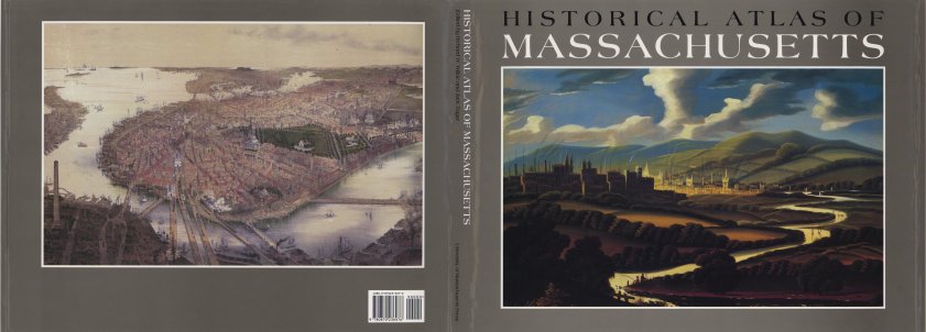
There is a similar atlas just for Massachusetts: The Historical Atlas of Massachusetts by Richard Wilkie and Jack Trager (1991), but the digital version is not quite as sophisticated.


The BP Energy Charting Tool

The BP Energy Charting Tool seems cool and I like the fact that you can grab the data, but I could not figure-out easily how to use it.

DHIS2

DHIS2 looks pretty great: flexible, web-based open-source information system with awesome visualization features including GIS, charts and pivot tables.

Wednesday, December 16, 2015

Thursday, December 10, 2015

I am worried about my grade

Good Videos!

These videos about climate change are not necessarily all that new, but It's Okay To Be Smart does a nice job synthesizing the complex issues into watchable videos:
  1. Climate Science: What You Need To Know
  2. Why People Don't Believe In Climate Science
  3. The Sixth Extinction
This goes along nicely: Short Answers to Hard Questions About Climate Change (Justin Gillis, NYT 28 November 2015)

World City Population 1950 - 2030

World City Population 1950 - 2030 is a nicely-done interactive map using stacked graduated symbols - and that actually works in this case. Also nice: a Map Guide and Analysis pop-up window is included.

Map of Gun Deaths

How Many People Have Been Shot Near You This Year? is exactly what it says it is: an interactive map of American gun violence.

Friday, December 4, 2015

Your Country's Energy Mix

I'm not really liking the viz, but the data and information shown is pretty great - this is basically a realistic blueprint for a largely carbon-free world by 2050. And by that a welcome antidote to all this push towards geoengineering as the only viable 'solution'. Have a look at How Could Your Country's Energy Mix Look?

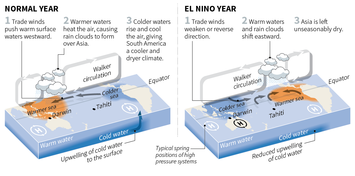
How El Nino affects weather

And a nice interactive chart of southern oscillation index: How El Nino affects weather


Gauging a warming world

Pretty impressive infographic / article by the Washington Post: Gauging a warming world

Thursday, December 3, 2015

Map Channels

Yep, Map Channels is yet another simple interactive web mapping platform draped over Google Maps.

Shifted Maps

The Quantified Self movement has been around for a while now, but lately has exploded with the advent of inexpensive 'fitness' trackers that everyone seems to be wearing on their wrists these days. Of course, you can also use your smartphone with the Moves app and then visualize the the collected data using Shifted Maps.

Six graphics that explain climate change

Six graphics that explain climate change by the BBC News is simple - perhaps too simple - but presents a nice introduction to the issues of modern-day human-caused climate change. The key figure is the last one in my opinion.

Plan A, Plan B, or Plan C

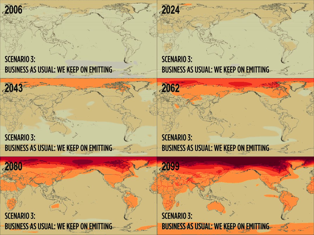
How Will The Earth Warm? It Depends are three nice and simple animated GIFs showing three different versions of global warming until the end of the century that depend on our choices today. Here's the BAU future:


Plume Air Report

The Plume Air Report claims to be the first worldwide interactive map of air pollution. I don't think that's entirely correct, for example see The World Air Quality Index Project or this effort by Yale University.

D3plus

D3plus makes interactive data-vz using D3 easier and that's a good thing for us non-JavaScript nerds. Plan B: use Plotly.

Sunday, November 29, 2015

The Pledge Gap

The Climate Change Pledges Are In. Will They Fix Anything? is a nice data viz by the New York Times of CO2 emission reduction pledges in the context of the Paris Climate Change Conference. Scroll-down all the way for the take-home message: what future do you want?

Friday, November 27, 2015

Tuesday, November 24, 2015

Saturday, November 21, 2015

Mapping History!

These visualization of history are just cool!
  • Histography provides an interactive timeline of history (based on Wikipedia) for the last 13.8 Billion years.
  • The Museum of the World is an interactive experience mapping time, continents, and cultures.

Tornado Tracks 1950 to 2014

Tornado Tracks 1950 to 2014 is a nice interactive web map (using Esri ArcGIS Online) showing tornado tracks between 1950 and 2014: clean, simple, and useful.

Thursday, November 19, 2015

The Dreaded Non-Zero Y-Axis

Climate Change Mitigation Policies

Tree Canopy Assessment Tool

Could be useful: Tree Canopy Assessment Tool

Drought Mapping using CartoDB

This is a great tutorial: Make a Thematic Map of Current Drought Conditions (using CartoDB)

D3.js and R

Better Data Visualization with Python, D3.js, MapReduce and R has some nice information and links related to those four data analysis and visualization tools, for example:

The Breathing Earth

Saturday, November 14, 2015

ThingLink

ThingLink is fun and basically a simpler version of StoryMap JS: upload an image and make it interactive by adding tags and linking to multimedia. In other words: make a story map from an image - be that of some natural feature, art, or whatever.

Here's a fun example: GPS Survey of the Quelccaya Ice Cap

Now That's A Map!

Well-written: Equal Area Cartograms and Multivariate Labels with several great examples, including this one:


Geocaching, GPS, and More

New webinar by JoeKerski on Geocaching, GPS, and Related Geo-Activities - should be fun and useful!

Windyty Weather Forecast

These types of visualizations have been around, but Windyty now includes the wind, temperature, pressure, cloud, and humidity forecast for the next few days. Plus, you can change the altitude to see how the winds change as you go up in the atmosphere. And you can change between 2D and 3D modes, plus choose different base maps.

Deforestation in Brazil

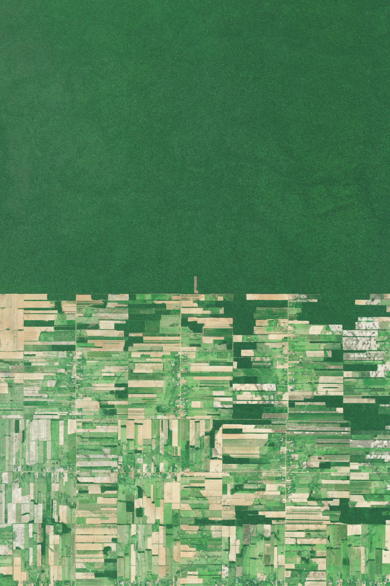
NPR Look At This has a powerful photographic journal of rain forest deforestation in Brazil (which includes a few maps). This is a nice example of story mapping without really any maps.

Wednesday, November 11, 2015

ArcGIS 10 Tutorial

This is pretty great: a hyper-texted and illustrated tutorial for ArcGIS 10 by the folks from Amherst College.

SHOW by Mapping Worlds

SHOW by Mapping Worlds makes interactive cartograms of countries, US states, or Japan prefectures and you can get the data as MS Excel spreadsheets - nice!

TeachGIS.org

Teach GIS is a venue where expert and novice instructors of geographic information systems (GIS), and related geospatial technologies, could feel comfortable sharing ideas, asking and answering questions, and learning from one another. We are software neutral and very open-minded towards open source tools. We welcome any and all fellow GIS instructors from our wider global community to join the conversation.

The Lab Activities section hosts a nice searchable version of Esri's Spatial Labs.

Esri Spatial Labs

Esri Spatial Labs are standalone activities designed to promote spatial reasoning and analysis skills. In other words: they are boring. But, together with authentic place-based question they can serve as intellectual stimuli as well as opportunities to practice tools and techniques. Download the entire package as a 2.3 GB zipped ISO file.

MapWorks

MapWorks is fun and useful and allows you to style and annotate an OSM map and to download your map as a PNG or SVG file.

Ecological Land Units

Or: a new map of the global ecosystem - explore:

Africa Map

Africa Map is a comprehensive mash-up of many data layers from Africa (using Harvard's WorldMap web mapping tool).

The American Time Use Survey

I had no idea such a thing existed until I saw the The American Time Use Survey visualized at Counting the Hours on FlowingData. And there is even ATUS-X, a website by the University of Minnesota where you can easily download the data.

US Crime in 2013

Nicely-done in R Studio: US Crime in 2013

Evernote

I used to be an Evernote user and then switch to Trello for task management and Google Docs/Drive for everything else. Still, the speech-to-text feature in Evernote is appealing: in theory it transcribes your voice notes.

Esri Survey 123

Survey 123 for ArcGIS looks useful - a tool/app to facilitate field surveys and field data collection using tablets. There is more about it in the Survey123Community on GitHub and in ArcNews (Fall 2015).

Fun with GIS 191: Survey 123 helps you to get started and Charlie Fitzpatrick also created a nice sample activity with a sample spreadsheet.

SIGMA

The System for Integrated Geoscience MApping (SIGMA) by the British Geological Survey is a tool for field data collection, mapping, and visualization running on Windows and using ArcGIS 10 and MS Access 2007.

ASTER GEDv3

The ASTER GEDv3 offers TIR data from 2000 to 2008 at 3 arc sec (~100 m) resolution - cool!

Monday, November 9, 2015

Saturday, November 7, 2015

Commons Lab

Commons Lab is (as they state on the website) a database of federal crowdsourcing and citizen science projects. Somehow I'm not impressed...am I missing something here?

Thursday, November 5, 2015

Saturday, October 31, 2015

Student Debt and Income

Here are two interesting data viz related to student debt and income:
  1. This app / data viz (using R) allows you to compare several colleges and universities side-by-side in terms of student debt, cost, and other variables.
  2. More mundane (maybe) is the most recent college ranking by the Economist comparing actual vs. expected income after graduation.
Both seem to be inspired and driven by a large data set released recently under the auspices of the College Scorecard initiative.

Food Access Mashup

Here's a simple mashup of data layers relevant to the issue of food access - nothing fancy in terms of analytics, but nevertheless a nice and simple way to tell the story. Maybe more interesting is Community Commons and the online mapping tools included.


Using CartoDB

CartoDB is one of these hip new online mapping environments and here is a selection of useful resources:

Thursday, October 29, 2015

Mapping Runs

Where People Run in Major Cities is nothing new, but the resultant maps are beautiful. Here's RunKeeper and Strava - these are actually quite useful when looking to discover new areas for trail running and mountain biking.

Of course, you can also have fun with this, for example Running Drawing by Claire Wykoff.

Mapping James Bond

This Esri story map got a lot of attention: The James Bond Travel Map.

Wednesday, October 28, 2015

Tuesday, October 27, 2015

Greenland Is Melting Away

Greenland Is Melting Away is nothing new in terms of science, but a great multi-media viz by the New York Times. Here are the direct links to the two videos:
There is also a nice side story about collecting drone footage over the Greenland Ice Sheet at A Drone’s Vantage Point of a Melting Greenland with this video:

Saturday, October 24, 2015

DSCOVR:EPIC

DSCOVR:EPIC are daily full images of our Earth from space using the EPIC camera flying aboard the Deep Space Climate Observatory (DSCOVR) satellite (read more about it here).


Climate Change is here.

Climate Change is here. is an online special by National Geographic organized into three sections: science, mitigation, and adaptation. As you would expect, the visuals are stunning.

Tuesday, October 20, 2015

Monday, October 19, 2015

Awesome Data Viz

15 Stunning Data Visualizations is a) a great compilation and b) includes a nice explanation of why a particular data viz is stunning.

The Seasonal Cycle

Nice and simple - just click the Play button and watch the seasons change on County Climate.

Saturday, October 17, 2015

Dropchop

Dropchop.io is a browser-based GIS based on Mapbox and Turf.js (according to Maps Mania). There - that's all I know about it. But it seems pretty cool playing around with it - you can actually perform some pretty sophisticated geospatial analysis.

Friday, October 16, 2015

Global Air Quality in Real-Time

The World Air Quality Index Project provides just that: a global map of air quality in real-time:

Wednesday, October 14, 2015

Sea Level Rise

The folks @ Climate Central are producing some great interactive maps visualizing the impacts of sea level rise on coastal communities in the USA with their Surging Seas analysis. Here is a simplified version as an interactive and embeddable map:

Urban Sprawl Manila 1988 to 2014

NASA produced an interesting image comparison showing urban sprawl around Manila between 1988 and 2014 using Landsat images. Nothing new here, but a nice example of the benefits of a long satellite image archive,

3D World Elevation

If nothing else: cool! 3D World Elevation

Monday, October 12, 2015

El Nino!

File Conversions

Getting things (i.e. data) from one software to the next used to be much more of an issue...nowadays most software programs have pretty comprehensive import/export options. If all failed - at least for GIS data, there is GPSBabel and now a new online file conversion tool from Golden Software (also free, but requires registration).

Friday, October 9, 2015

Earthquakes in 3D

Nothing really new here, except the earthquake data for the last 100 years is now draped over a 3D globle: One Hundred Years of Seismic Activity. Cool? Yes! Necessary? No!

Landslides!

This is pretty good - except for the title: When Nature Strikes: Landslides

Thursday, October 8, 2015

Fleeing Syria for Europe

A beautifully-designed and narrated story map: Fleeing Syria for Europe: Safaa's fatal journey

Diabetes and Immigration

Here are two recent interactive data infographics that combine it all: maps, charts, tables, spark lines, etc. - impressive!
But - what's missing: a link to download the data!

Wednesday, October 7, 2015

30 Years of MS Excel

Urban Density

There is no such thing as a city that has run out of room is a nice and simple data viz by the Washington Post: scroll-down a bit and compare different urban areas around the world.


Rising and Descending Air

Rising and Descending Air

Undercast Timelapse 10-06-15
Good Wednesday morning! Summit intern Adam Gill captured this timelapse footage yesterday afternoon of clouds rising up over the Northern Presidentials, before descending into the Great Gulf and dissipating.
Posted by Mount Washington Observatory on Wednesday, October 7, 2015

Sunday, October 4, 2015

Mars!

Lot's of Mars maps recently - for good reason!
  1. Discovering Liquid Water on Mars
  2. Where on Mars?
  3. The Martian Map
  4. Bing Watney Home!

Mapping the USPS

Mapping the USPS Facility Network is pretty disturbing: enter an origin and a destination and see how and where your mail travels as it moves through the USPS network of facilities. I tried, as an example, sending a letter from my home to my office and it traveled 130 miles (compared to the shortest route of 47 miles).

Sunday, September 27, 2015

Naomi and Francis

Naomi Oreskes always has interesting things to say about the nexus between climate science and its political, social, and economic implications. Have a look at the recent piece As Pope Francis Meets America, a Climate Science Scholar Offers a Fresh View of the Encyclical for her thoughts on that.

Thursday, September 24, 2015

Tuesday, September 22, 2015

Sustainable Growth and Resilience Data Gateway

Talk about packing buzz words into a title: Gateway Supports Sustainable Growth and Resilience. Unfortunately, the actual data gateway is far less impressive in terms of design, functionality, and available data.

Friday, September 18, 2015

AIDSVu

AIDSVu is impressive: interactive mapping of HIV/AIDS data at the city, county, and state level. Plus, all the data are available for download and you can even create your own maps as PDFs or PPTs.

Fall Hard / Stand Tall

Here we have the total opposite: Fall Hard / Stand Tall is a rich and interactive data viz of NFL player height and weight created with Tableau.

How Your State Generates Power

Subtle, clean, and simple: Coal, Gas, Nuclear, Hydro? How Your State Generates Power

MS Excel and ArcGIS

The source of many frustrations - how do you best take data from MS Excel into ArcGIS? Formatting a table for use in ArcGIS includes useful tips and tricks!


Thursday, September 17, 2015

Atomic

Atomic is a brand-new web-based interactive and collaborative design tool - read a review by John Brownlee over at Co.DESIGN. According to him Atomic is free for education and academic use, although their pricing information is pretty vague at this point.

Overview of Atomic from Atomic on Vimeo.

And - But - Therefore

Houston, We Have A Narrative is a new book by Randy Olson that helps scientists tell their stories in a compelling way using the _____ and ______, but ______, therefore _____ framework. Andy Revkin offers his review over at Dot Earth and you can listen to a Randy Olson podcast over at The Prism.

Other books by Randy Olson include Don't Be Such A Scientist and Connection: Hollywood Storytelling meets Critical Thinking (also available as an app for Android and iOS).

Wednesday, September 16, 2015

Satellite Surfer

Seen on Maps Mania: The Satellite Surfer tracks 88 satellites live and in real-time. Plus, the pass predication option allows you to - well - predict satellite overpasses based on a location and time. It loads a bit slow, but is worth the wait.

The Living Wage Map

Nothing super-special here: The Living Wage Map is simply a nice and clean implementation of a story map.

Tableau Public 9.1

Tableau Public 9.1 was just launched - a great way to tell web-based data stories.

Tuesday, September 15, 2015

The Carbon Map

Simple and clean: The Carbon Map is a series of cartograms telling the story of global climate change

Smart Charting

This is super-hip right now: smart mapping or smart charting where the software looks at your data and automatically suggests appropriate visualizations and analytical steps. Convenient? Yes! But also scary for a teacher...students have to think even less now.

Anyways, here is what Nathan Yau had to say about Google's new Explore option: Automatic charts and insights in Google Sheets.

Sunday, September 13, 2015

WorldClim

WorldClim provides global gridded climate data at various resolutions: observed (1950 to 2000), future (CMIP5 data), and past conditions. What's nice here is that the data are provided in file formats easily used in a GIS, for example GeoTIFF or Esri GRID.

Classic!

Saturday, September 12, 2015

Green Roofs

Green roofs are pretty hip these days and the GRITLAB at the University of Toronto is clearly the place to learn about them (and green walls).

Friday, September 11, 2015

Need MS Excel?

Let's be honest: all the cool stuff is nice, but in reality we all still need to use (and understand) a basic spreadsheet software, for example MS Excel. Here are some great links in case you need a refresher or want to see some more advanced applications:
  1. The Absolute Beginner's Guide to Spreadsheets (Ann K. Emery)
  2. Learn Excel: An In-Depth, Thorough Tutorial (With GIFs) (Ann K. Emery)
  3. MS Excel on Steroids!
  4. Excel Map Hack (John Nelson)
  5. More assorted good stuff
  6. Excel Mini Tutorials on YouTube (Barb Henderson)

EarthViewer

How about using 3D virtual globes to look at the Earth millions of years ago? EarthViewer (by HHMI) is great, especially as you can download and run it locally (great for schools with slow Internet). HHMI also offers great resources, classroom activities, and more for EarthViewer.

What Did the World Look Like is a simpler, fully-online implementation.

Sunday, September 6, 2015

The Everything Machine

Super-cool from the folks at Tinybop: The Everything Machine allows to to program your own apps that use all the components of an iPhone or iPad (e.g. camera, microphone, etc.) in a fun, lego-style interface. Here's a review on Co.DESIGN.

Also really cool: Simple Machines and Robot Factory.

Piktochart

Piktochart has been around for a while as a web-based tool for designing infographics. Julie Platt on ProfHacker recently provided a review and discussion of how she uses Piktochart for creating visually-appealing course materials such as course syllabi, etc.

I agree with her basic argument: we live in a visual world and therefore the visual design of our course materials is important and sets an example for what we expect from our students.

Statistical Jargon

Good tips and explanations here: Plain Languaging Statistical Jargon. Her main argument: don't add confidence intervals, etc. to your charts unless you can explain them in a concise text box or sub-title.

Saturday, September 5, 2015

Dot Maps

Dot maps are pretty cool - you use 1 dot to represent say 1 job or 1 person or 25 renters/owners or 20 immigrants. The problem is really performance...these maps tend to take a long time to load.

Thursday, September 3, 2015

Pixel Map Generator

Via Maps Mania: The Pixel Map Generator enables you to create highly-stylized (i.e. pixelated) maps which may be useful for illustrative purposes or as base layers.


Arctic Ocean Sea Ice 2006 to Current

Arctic Sea Ice by mastermaps is a really nice and subtle viz of Arctic Ocean sea ice conditions - combining daily and annual data as a line graph and a polar-projection map.

Wednesday, September 2, 2015

Playground Physics

And other fun and educational apps for the iPad - introducing Noticing Tools by the New York Hall of Science. Read more over at Co.DESIGN or risk $9.99 to try them.


Friday, August 28, 2015

Mapping Segregation

Mapping Segregation (by the NYT) is basically the interactive version of the famous Racial Dot Map by Dustin Cable.

Remote Sensing and Water Resources

This is not new: remote sensing is a great tool to monitor water resources such as lake levels, flooding, etc. Less known is the application of GRACE - a satellite mission that effectively weighs the Earth - and how it can be used to monitor groundwater resources. Read more here.

This image below is a nice example using the ongoing drought in California as an example:

Wednesday, August 26, 2015

Katrina +10

Esri just released a new story map called Katrina +10 visualizing the aftermath of Hurricane Katrina and what has happened over the last 10 years.

Friday, August 21, 2015

Public Health Data

The CDC is a pretty impressive source of public health data, but (as usual...) it's difficult to find what you are looking for. The Diabetes section, however, is an example of a well-organized data portal, nicely organized at the national, state, and county level.

The 10 Largest Cities in the US

Mapping the westward-shifting center of the US population is nothing new, see for example Population Drift from 2011. But how about the changing spatial distribution of the 10 largest US cities (by population) over time? Keir Clarke has a nice post on that over at Maps Mania and created Shifting Cities. A Historical Look At America's Largest Cities is a similar interactive map (using Tableau) and below is a simpler version as an animated GIF.

http://imgur.com/tWE7i

Thursday, August 20, 2015

Mapping drought and precipitation

Two interactive maps by EcoWest:
  1. Tracking U.S. Drought Severity
  2. Rain and Snow in the U.S. Since 1981
I don't know...something does not work with this data viz for me...

Science is really hard!

Excellent piece by Christie Aschwanden Science Isn't Broken -  It’s just a hell of a lot harder than we give it credit for. Good and easy to digest illustrations of one of the most basic statistic concepts used in science: the (dreaded) p-value and the 0.05 value. The interactive data cruncher is great!

Science, even if it appears simple, requires a lot of choices that can shape the results down the road. P-hacking is less of an issue in the physical and natural sciences. But, yes, we do practice HARKing (at times) = hypothesizing after the data have been collected. Why? We all want to a) find cool results and b) prove something. That's a) human nature and b) needed for a successful career.


Still, science remains the most rigorous path to knowledge that we know of - and that really means 'getting less wrong' over time. Our current state of knowledge is only our best estimate of 'the truth'.

And that we don't teach well. We pretend science is easy as long as you follow the regiment of the scientific method and then make a poster for your school science fair. Science = done! In reality you ask a question, do a study, and get a partial / ambiguous answer. And then it continues.


Tuesday, August 18, 2015

The true size of...

The true size of... is pretty clever: enter the name of a country and see its size change as you drag it around the Mercator map. Read about it here. My favorite: Brazil vs. the USA:


Monday, August 17, 2015

100 Percent?

I have seen this as an image, but here is the associated video:

Saturday, August 15, 2015

Mapping the Arctic (1999 to 2014)

This has gotten a bit too much news relative to its relevance: National Geographic had to revise their maps of the Arctic as sea ice is disappearing due to global warming.

1999 to 2014

Teen Birth Rates 1990 - 2013

U.S. and State Trends on Teen Births, 1990–2013 as an interactive map and charts created using Tableau.

Wednesday, August 12, 2015

Landsat Lens

Landsat Lens is fun: search for a place and see how it changed from 1975, 1990, 2000, 2005, and 2010 using the public Landsat archive. A series of good (and well-known) examples are provided on the left.

I like the clean and simple interface, but there are two issues (none of which are the responsibility of the author). First, it's slow...it takes a long time for the Landsat scenes to load. Second, Landsat with its 15/30 m resolution since 1990 (worse in 1975) is just not cutting it anymore if you are used to seeing the awesome commercial high-res images and data from Airbus, GeoEye, DigitalGlobe, LiDAR, etc. Don't get me wrong: Landsat was (and is) great for what it was (and is) = a globally-consistent and free satellite image data set, but it is frustrating as a scientist to not have access to the commercial data (which are prohibitively expensive).

Killing the Colorado

Via Maps Mania: Killing the Colorado is an awesome interactive map-based web-based visualization...in other words what Esri calls  Story Map.

Here's one part: Welcome to Fabulous Las Vegas showing the urban sprawl of Las Vegas since 1975 (= the start of the Landsat era).

Tuesday, August 11, 2015

The ocean floor in 3D (or 2D)

This is well-done: Seafloor Lithology 1.0 is a 3D (or 2D) interactive map of the ocean floor (I especially like the Columbus view). More information here.

What's across the ocean from you?

Fun! See more maps here.


Currents in the Air, Ocean, and Lakes

These have been around, but always awesome!
Here's Esri's version of the global wind map on GitHub.


Monday, August 10, 2015

Advancing the map in US 8th grade Earth Science

Something new from Esri: Earth Science GeoInquiries = new instructional resources designed for the US 8th grade Earth Science class. Read more about it here.

Infographics & Data Visualizations

If you can handle it: here are the 1715 best infographics & data visualizations as compiled by Visualloop.

Teachers as Sports Stars!

Very funny: Teaching Center

What is machine learning?

Here's a nice visual introduction, aptly called A Visual Introduction to Machine Learning. This is nothing new to those familiar with remote sensing and image analysis - machine learning is really just a new fancy word for image classification (both supervised and unsupervised).


Road Trip!

Well, at least in terms of literary classics: Atlas Obscura's Guide to Literary Road Trips. One quibble: the map is missing The Grapes of Wrath!

STD Cities

This map is a bit misleading - it only provides data for what appear to be the largest cities in each county, but interesting nonetheless.

This map about STD statistics was created and produced by RentApplication.com . You may share and embed this map with proper attribution.

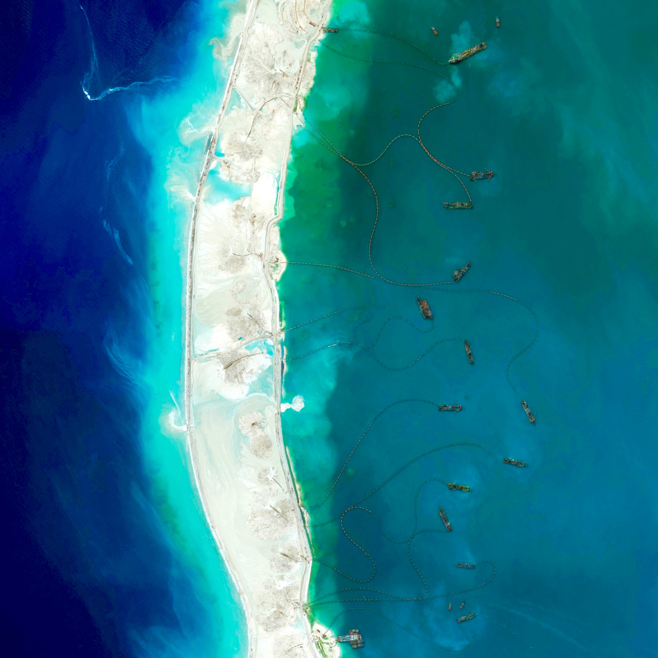
Making new land...

What China Has Been Building in the South China Sea ran in the NYT on 31 July 2015 - the animation at the top is great. If only we could gain access to satellite images like that...

Below is an image from the Daily Overview showing one of the new islands ("Mischief Reef") connected to surrounding by dredgers pumping sediment from the ocean floor onto the reef to make it larger.


Why we need driver-less cars!

Via Mark Wilson @ Co.DESIGN: This Cute Simulation Proves Why We Need Driverless Cars

How brand-new words are spreading across America

Cool: How brand-new words are spreading across America

Elastic Topography

Seen on Maps Mania: Elastic Terrain Map by The Cartography and Geovisualization Group at Oregon State University. Pretty useless, but super-cool!

Textbooks

College Textbook Prices Have Risen 1,041 Percent Since 1977