Geography = a macroscope for dealing with complex human and natural systems. Read more about it here: http://www.appreciatingsystems.com/wp-content/uploads/2011/05/The-Macroscope.pdf
Wednesday, June 21, 2017
Sunday, June 18, 2017
The Animated GIF
What Makes The GIF Great is a nice history of the GIF, invented 30 years ago!
 |
| https://www.fastcodesign.com/90129895/what-makes-the-gif-great |
Worldmap Generator
Choose your projection, zoom, center, etc. with Worldmap Generator and see that indeed the world in 2D can look however you want it to look!
Friday, June 16, 2017
Making Air Visible!
Excellent video by Veritasium: Seeing the Invisible (embedded below). The NPR Skunk Bear showed something similar a couple of years ago: Seeing Thin Air (showing work by RIT students).
Thursday, June 15, 2017
One Year In The Life of Earth
One Year In The Life of Earth (by NASA) offers some nice videos from the EPIC camera on NOAA's DSCOVR satellite. Below is the simple animated GIF.
2016 Election by Precinct
Below is the MA map: this would be so much better with town lines as context! And: as an interactive map. Maps of the other states and the USA as a whole are at 2016 Presidential General Election Maps.
 |
| http://rynerohla.com/wp-content/uploads/2016/12/16-MA-Inverted.png |
Thursday, June 8, 2017
Tuesday, June 6, 2017
What Do Your Country's Emissions Look Like?
Here's nice (albeit complicated) interactive infographic breaking-down GHG emissions in 2012: Global Top 10 Greenhouse Gas Emitters (here are the data).
Friday, June 2, 2017
SLR by NOAA
NOAA has a nice SLR Viewer with all the usual features, including an easy download link to the underlying data.
Thursday, June 1, 2017
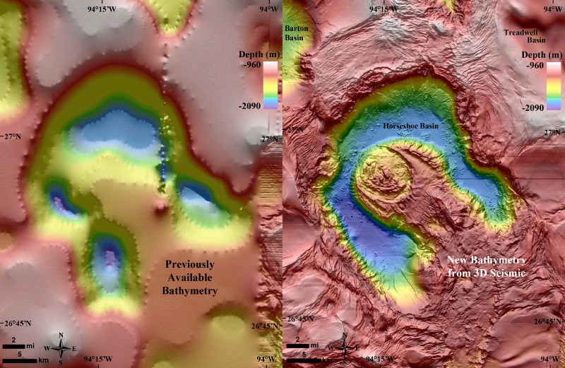
A 1.4-Billion-Pixel Map of the Gulf of Mexico Seafloor
Who knew that we have a federal agency called the U.S. Bureau of Ocean Energy Management? I'm not quite sure what they do, but they just released a stunning bathymetry grid for the Gulf of Mexico. Read more about in EOS: A 1.4-Billion-Pixel Map of the Gulf of Mexico Seafloor.
Subscribe to:
Comments (Atom)


